Research on Citizen Science as a promoter of geographic literacy is being carried out by doctoral student Dalit Lan, under the guidance of Associate Prof. Ayelet Baram-Tsabari, The Faculty of Education in Science and Technology and Dr. Sagi Dalyot, Faculty of Civil and Environmental Engineering. The research was conducted within the Center of TCSS (Taking Citizen Science to School) jointly with the Technion and the University of Haifa.
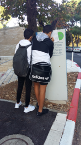
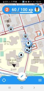
The study examines the integration of Citizen Science research in the field of mapping and geo-information, in Geographic Education. Students, as Geographic Information Volunteers, take part in social participatory mapping. The study will allow planning of walking paths for the visually impaired- blind population. The route calculation and detection will be performed using an algorithm, relying on the mapping data that students collect on the open platform- OpenStreetMap. The Mundi app was developed to collect information that will enable the calculation of the routes. (See an explanation about the Mundi app and the scientific research led by Dr. Sagi Dalyot).
To promote the students’ geographic literacy and social involvement, various models have been developed for project integration in schools.
The students participate in an intervention program that includes the development of skills, knowledge and understanding in the field of Geographic Information Systems as part of geographic inquiry based learning. The study examines aspects of geographic literacy, spatial thinking and active citizenship in the context of integrating Citizen Science into the school. Schools wishing to participate in the project can also incorporate the Ministry of Education’s program for community social engagement.
The Covid-19 pandemic created the need to develop a distance learning model, which included online sessions and learning through videotaped lessons. Participatory mapping is a type of place-based extracurricular learning, held in accordance with the limitations of social distance. Four schools participated in this model in 2020-21.
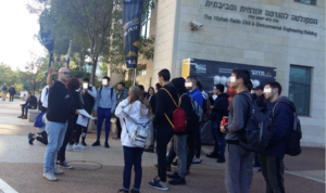
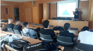
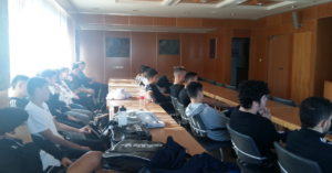
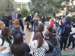
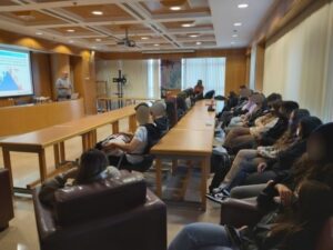
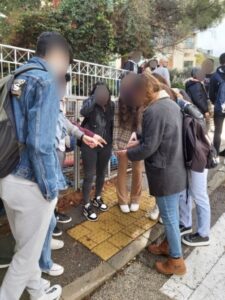
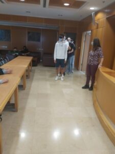
The 2021-2022 school year enabled face-to-face learning that incorporates distance learning – a hybrid learning model. As part of the learning and partnership with the scientist, Dr. Sagi Dalyot, education researcher Dalit Lan, the teachers and the students visited the Technion Institute, met with Dr. Sagi Dalyot, and mapped using the application throughout the Technion.
A learning environment has been designed for the project, which includes a filmed lessons, activities and instructions. The modular learning environment was tailored to suite the goals and needs of each teacher. The curriculum was designed in collaboration with the education researcher and the teachers. It includes various topics in the field of geo-information, geographic civic science and its contribution to society and science, on the difficulties of people with blindness and accessibility of space and social spatial equality and geographical cyber skills. The integration of the project in schools in different models was presented at the conference “Geographic Cyber - 2021” – Geographic citizen science as a promoter of spatial geographic literacy.
The educational research that accompanied the project investigated in what ways students’ geographic literacy shaped by their participation in a citizen science project?
In phase A of the research, 162 students participated in three different integration models. Preliminary results from questionnaires and semi-structured interviews suggest that participation in the project can increase geo-spatial thinking as well as students’ self-esteem with respect to their knowledge and use of geographic skills.
Also that a broad intervention model can increase students’ appreciation of the scientists’ contribution to the project, the contribution of the program, and satisfaction with their participation in the program.
The Students also participated in a research that examined the understanding of students in the context of the information presented in the maps, in the context of the Covid-19 pandemic.
The findings show that the geographical literacy of students who participated in the project was higher than that of students who did not participate in the project.
One of the conclusions is that curricula that incorporate citizen science based on participatory mapping can enhance students’ geographic literacy.
At the Geographical Association Conference, 2021, findings and insights emerged from the students’ and adults’ surveys in the lecture – Examining geographical literacy skills among school students: A case study of the COVID-19 pandemic.
A poster presenting the research and the findings of phase A was presented on the research day of the Faculty of Science and Technology Education at the Technion. See here.
Schools interested in joining the project as part of geography, science or as a project to contribute to the community and social involvement, can contact Dalit Lan- lan.dalit@campus.technion.ac.il
 |
 |
 |
 |
 Dalit Lan |
 Sagi Dalyot |
 Ayelet Baram-Tsabari |